America's worst traffic: ATRI updates bottleneck list
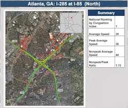
And for the second straight year the infamous "Spaghetti Junction," where Interstates 285 and 85 North converge outside of Atlanta, is the top freight highway bottleneck in the U.S., according to an annual study by the American Transportation Research Institute (ATRI).
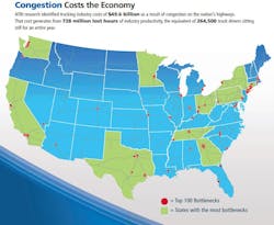
The group’s 2017 Top Truck Bottleneck List assesses the level of truck-oriented congestion at 250 locations on the national highway system; an analysis based on GPS data from 600,000-plus heavy duty trucks, several customized software applications, and what’s described as “terabytes of data” to effectively rank each freight congestion point.
The top 10 freight congestion bottlenecks in the U.S., according to ATRI’s data (click the links for detailed information on each location and traffic patterns), are:
- The intersection of Interstates 285 and 85 North outside Atlanta
- I-95 at State Route 4 in Fort Lee, NJ
- I-290 at I-90/94 in Chicago, IL
- I-65 at I-64/71 in Louisville, KY
- I-71 at I-75 in Cincinnati, OH
- SR 60 at SR 57 in Los Angeles, CA
- SR 18 at SR 167 in Auburn, WA
- I-45 at US 59 in Houston, TX
- I-75 at I-285 North in Atlanta
- I-5 at I-90 in Seattle, WA
"With President Trump expected to press for significant long-term infrastructure spending, this ATRI analysis should be a key guide for deciding what projects are worthy of funding," said Chris Spear, president of the American Trucking Associations (ATA) trade group, which is ATRI’s parent organization.
Indeed, the data and analysis used by ATRI to craft its annual freight highway bottleneck list can also be used to more effectively target roadway funding – especially if the Trump administration follows through on a trillion-dollar infrastructure spending proposal.
“We use that data to target [congestion] locations for our friends in the public sector for [roadway] investments,” said Brewster. “Our hope is that when infrastructure funding decisions are made, this data will be used to target the most critical areas.”
Murray added that no matter how large the Trump administration’s final infrastructure bill might be – $500 billion or even $ 1 trillion – when you get down to it, there will never be enough money to get every bridge and road fixed.
“So this data is a great targeting device,” he stressed. “Our data indicates that 89% of truck delays are associated with just 12% of the miles trucks travel. So there’s a huge targeting opportunity to address the main cause of truck delays; it allows for the development of a quick blueprint for [infrastructure] investments.”
Murray added that telematics providers are using ATRI’s bottleneck data to develop more “customized” routing; cobbling together routes by time-of-day data to avoid congestion trouble spots.
“It allows fleets to re-route or re-schedule themselves around chokepoints,” he said. “It also helps the providers develop roadmaps that avoid particular peak hour travel times.”
The GPS-based system can’t necessarily identify the exact reasons why freight congestion occurs at particular spots, either, Murray pointed out.
“Truth be told, it is difficult to understand the precise causes of congestion based on this data: is it [highway] reconstruction work? Is it the weather?” Murray said. “Over the last two to three years, in some cases, it’s been the improving economy; we cross-reference our traffic data with economic data and can clearly see that trend.”


