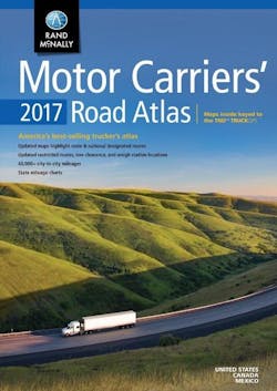
The paper map: Obsolete? Or old school trucker standby still?
Well, according a survey of 800 drivers Rand McNally conducted at the Mid America Trucking Show last month, the bulk of them still use paper maps in some shape or form – with 15% saying it’s their primary navigation tool.
I put this question to Barry Starr, a longtime driver with Powell Transportation (and no stranger to this blog), and he told me that though he uses the latest and greatest in GPS navigation technology, he still keeps a well-thumbed copy of Rand McNally’s ubiquitous road atlas close at hand.
“It rides right beside me every trip,” he told me from the road.
“I have a GPS on the dash [and] I use it a lot. But I use the atlas if I’m going someplace new or I’m using a new road I'm not familiar with to verify bridge heights, tolls, etc.,” Starr explained.
“I love new technology but am still old school as well,” he stressed. “That’s why I buy a new Atlas every year. It helps me keep up with truck route changes and weigh station locations.”
Stephen Fletcher, CEO of Rand McNally, noted that sentiment is one reason why his company keeps producing this paper road atlas every year, even though it offers its own line of navigation devices, including tablet computers:
"We’re continually evolving [our] line of truck GPS and electronic logging devices,” Fletcher said. “But despite advancements in technology for the truck and cab, many drivers still prefer to use a printed atlas for navigation. It continues to be a crucial tool for drivers whether as a back-up or simply to get a big picture view of their route.”
Rand McNally made a few upgrades to the 2017 edition of its truck-specific atlas, which of course includes thousands of map updates:
- Updated highways showing the latest truck roadways as designated by the Surface Transportation Assistance Act (STAA), also known as "designated" highways;
- Coverage of select Hazardous Materials Regulations;
- A 22-page mileage directory with more than 40,000 truck-route-specific, city-to-city mileages;
- Charts of state and provincial permit agency phone numbers and websites, low clearances, and weigh stations, as well as hotlines for road construction and conditions.
The company added that it also publishes a “large scale” edition of its storied atlas, one with maps that are 37% larger printed on laminated pages held together by a spiral binding so they stay flat.
Good to see that “old school” maps haven’t gone out of style yet.
[And for fun, check out this story about maps and how cartographers – the “official” name for map makers – went about fixing paper-based versions.]

