Tapping trucking telematics when foul weather strikes
Over the last several years, there’s been a noted uptick in weather-related telematics offerings within the trucking industry and now that technology is getting a workout in the aftermath of Hurricane Harvey.
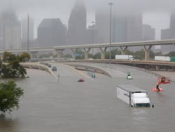
For example, Geotab just launched a time-lapse map, which will be updated weekly, to track commercial trucking activity in Houston and surrounding cities – especially in terms of highlighting road closures following massive flooding due to the storm.
The time-lapse map constructed by Geotab illustrates the impact of Hurricane Harvey by showing the drastic reduction in vehicles in the affected areas. Based on that data, the company said there’s been an 88% reduction in commercial fleet activity in the Houston area in one week alone, from August 21 to August 28.
“There are Geotab devices in approximately 52,000 vehicles in Texas, including 8,000 vehicles in the Houston area,” noted Neil Cawse, the company’s CEO, in a statement. “It is crucial that we do everything possible to help our customers protect the lives and safety of their drivers in the affected areas as we continue to face the outcome of this storm.”
He added that such data will help both commercial fleets and emergency responders to travel more safely, using real-time updates to detour around danger zones or make “complete stops” altogether.
Mark Hoekzema, chief meteorologist and director of meteorological operations at Earth Networks, noted in an interview earlier this year that raising the “safety factor” for truck drivers is one of the big benefits of combining weather data and telematics technology.
“The power of weather-driven telematics is amplified when external weather data is combined with road conditions data to provide a real-time snapshot of driving conditions,” he explained.
“By integrating forecast models with surface observations and road observation, including pavement temperatures, road conditions, and road treatment in each area, companies can improve fleet routing through enhanced efficiency and safety – while better managing loss prevention that can occur due to hazardous driving conditions,” Hoekzema pointed out.
“The ability to overlay real-time and forecasted weather data such as snow, hail, temperature, wind speed, lightning, wind gusts, etc. with road surface conditions holds the potential to significantly improve fleet operations, routing efficiency, and driver safety,” he added.
We’ll no doubt be seeing more examples of this weather-data/telematics combination as Hurricane Harvey recovery efforts begin to pick up steam.