Trimble MAPS app tracks truck stop availability

To ensure truckers are fully supported on the road during the COVID-19 pandemic, Trimble MAPS recently released a free web app called COVID-19 Safe Havens that takes crowdsourced data to identify where North American truckers can park to rest and which amenities are available at truck stops. It is available via mobile devices or desktop and does not require a login. The direct link is: covid19.trimblemaps.com.
The main intent is to help truckers get a better understanding of where they can stop to fulfill basic needs such as eating, sleeping, or using the restroom, which may or may not be available due to the coronavirus.
“Our drivers move hundreds of miles a day carrying emergency supplies and food to keep our country running. Yet, an important part of their support mechanism, the network of truck stops with food, fuel, showers, parking and accommodation, are partially or fully closed,” said Michael Pettrey, president of C&M Transport. “Using the COVID-19 Safe Haven web app from Trimble MAPS gives them peace of mind knowing the safe havens along their route as they complete their critical supply chain duties.”
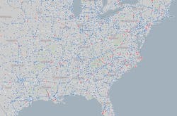
The map has different icons to differentiate Walmart stores, rest areas and gas stations. A red dot with a white dash over the marker indicates a closure. If drivers see a rest stop is closed, for example, they are encouraged to navigate to that area of the map, click on the icon, and hit the “closed” option.
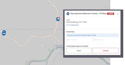
To let fellow drivers know where they can grab a bite to eat or knock out some laundry, they would click on that service to toggle between a green check mark for “available” and red X for “unavailable.” This will not instantaneously change the map. Each day, Trimble’s digital cartographers vet the various stops’ status by reaching out directly and fact-checking prior to updating the map, the company explained.
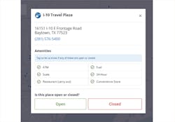
Trimble acknowledged the map may not be 100% accurate.
The digital tool also has a search bar so drivers and fleet managers can find a specific truck stop chain in whatever state they want to better pre-plan breaks. The app can also be connected to current transportation management systems (TMS).
“[Trimble] made it very easy for us to quickly integrate their driver safe haven interactive map with our TMS and our driver mobile app, Circle Mobile,” said Stuart Sutton, president and CEO of Full Circle TMS. “We all have a responsibility to minimize the impact of COVID-19 on the supply chain. Thanks to Trimble MAPS, giving drivers easy access to this powerful safe-haven tool helps meet that responsibility.”
About the Author
FleetOwner Staff
Our Editorial Team
Kevin Jones, Editorial Director, Commercial Vehicle Group
Josh Fisher, Editor-in-Chief
Jade Brasher, Senior Editor
Jeremy Wolfe, Editor
Jenna Hume, Digital Editor
Eric Van Egeren, Art Director